Trail Walking La Giettaz - Le Plan - col de Jaillet - Photo

Le Plan - col de Jaillet

 wbarge
wbarge

User

© OpenStreetMap contributors
Length
Length
11.9 km
Max alt
Max alt
1731 m
Uphill gradient
Uphill gradient
589 m
Km-Effort
Km-Effort  
19.7 km
Min alt
Min alt
1225 m
Downhill gradient
Downhill gradient
589 m
Boucle
Boucle
Yes
Creation date :
2014-12-10 00:00:00.0
Updated on :
2014-12-10 00:00:00.0

(2 Reviews)

Walking
Walking
4h18
Difficulty : Medium

Scan this QR Code to open this trail in the SityTrail application

FREE GPS app for hiking

Logo SityTrail SityTrail

IGN / Geographical institutes

Download SityTrail from the App Store Download SityTrail from Google Play

Logo SityTrail SityTrail World

The world is yours!

Download SityTrail from the App Store Download SityTrail from Google Play Download SityTrail on Huawei AppGallery

About

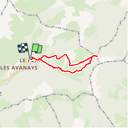
Trail Walking of 11.9 km to be discovered at Auvergne-Rhône-Alpes, Savoy, La Giettaz. This trail is proposed by wbarge.

Description

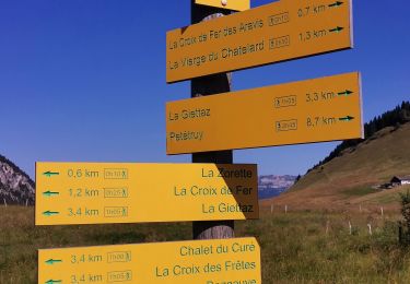
Départ du parking du Plan à côté de l'église. Puis direction de Ramadieu. Arrivé après un champs à vaches (bien qu'il est écrit attention moutons), à la bifurcation tête de Ramadieu, prendre direction col de Jaillet (d'ailleurs à ce niveau vous aurez un point de vue formidable). Ensuite direction le col de Jaillet (presque que du plat). Pour la descente vers le Pan nous avon spris le chemin vers le planet (moins intéressant question vue).

Elevation profile

Photos

Positioning

Country:
France
Region :
Auvergne-Rhône-Alpes
Department/Province :
Savoy
Municipality :
La Giettaz
Location:
Unknown
Start:(UTM)
307924 ; 5083656 (32T) N.

Comments

Please log in to post a review or rate the element


Super randonnée 👍👍


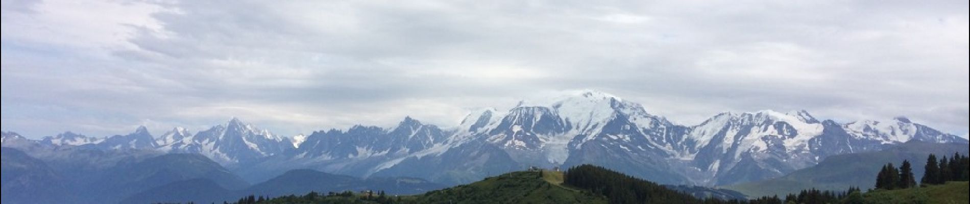
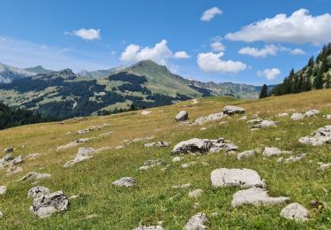
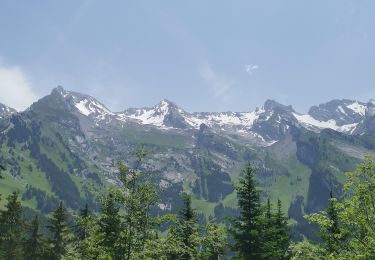
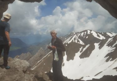
Très belle randonnée qui monte en sous-bois dans un terrain très souple avec en récompense un paysage sublime sur les chaînes du Mont-Blanc idéal pour un jour de grande chaleur et de beau temps pour profiter de la vue


Trails nearby

Trail Walking La Giettaz - Boucle de Croisse Baulet - Photo
Walking
olivecoco

Walking

Medium
(1)
La Giettaz, Auvergne-Rhône-Alpes, Savoy, France
9.4 km | 23 km-effort
4h 2min
Yes
Trail Snowshoes La Clusaz - col aravis - Photo
Snowshoes
myjackotte

Snowshoes

Easy
(2)
La Clusaz, Auvergne-Rhône-Alpes, Upper Savoy, France
5.7 km | 8.2 km-effort
2h 16min
Yes
Trail Walking La Clusaz - confins - Trou de la mouche - Photo
Walking
sofracoan

Walking

Medium
(1)
La Clusaz, Auvergne-Rhône-Alpes, Upper Savoy, France
9.5 km | 23 km-effort
4h 38min
Yes
Trail Other activity La Giettaz - croise baulet - Photo
Other activity
twistss

Other activity

Very easy
(3)
La Giettaz, Auvergne-Rhône-Alpes, Savoy, France
12.1 km | 27 km-effort
3h 30min
Yes
Trail Motor La Giettaz - La Giettaz - Col des Aravis - Photo
Motor
albertville

Motor

Very easy
(1)
La Giettaz, Auvergne-Rhône-Alpes, Savoy, France
15.8 km | 23 km-effort
58min
No
Trail Walking La Clusaz - TROU DE LA MOUCHE - Photo
Walking
Jean-Paulchoux

Walking

Difficult
La Clusaz, Auvergne-Rhône-Alpes, Upper Savoy, France
10 km | 24 km-effort
6h 7min
Yes
Trail Walking La Clusaz - Col des ARAVIS ... la Croix des Frêtes. - Photo
Walking
GerardBouche

Walking

Difficult
La Clusaz, Auvergne-Rhône-Alpes, Upper Savoy, France
7.4 km | 12.1 km-effort
2h 14min
Yes
Trail Walking La Clusaz - La CLUSAZ  ... la Tête du Danay. - Photo
Walking
GerardBouche

Walking

Medium
La Clusaz, Auvergne-Rhône-Alpes, Upper Savoy, France
8.2 km | 13.8 km-effort
2h 32min
Yes
Trail Walking La Clusaz - le trou de la mouche  - Photo
Walking
carton-fils@orange.fr

Walking

Very difficult
La Clusaz, Auvergne-Rhône-Alpes, Upper Savoy, France
8.9 km | 22 km-effort
4h 44min
Yes


Close
My subscriptions